![]() Background |
Models |
Projects |
Publications |
People |
News
Background |
Models |
Projects |
Publications |
People |
News
![]() Background |
Models |
Projects |
Publications |
People |
News
Background |
Models |
Projects |
Publications |
People |
News
Introduction
Conceptual model: South Florida
Wetland ecological models
Generic modeling framework
 It has been rightly said that "All models are wrong - some are useful". Simulation models are explicit abstractions of reality, and at best are tools that should provide insights into a better understanding of a particular problem. Abstractions cannot be perfectly accurate representations of reality.
With this in mind, we provide an overview of an existing model framework that was designed to be general enough to increase our synthesis and understanding of integrated ecosystem dynamics within large spatial domains, and across decadal ecological time scales.
While there are often multiple stakeholders with conflicting goals in any particular project, the Projects and Publications sections of this site demonstrate that our various model applications have been "useful" - in the context of understanding, managing and restoring important landscapes.
Below is a broad summary of the generic modeling framework, which is then further explained in the Models and Projects sections of this website.
The landscape modeling framework that is outlined here is intended to be flexible and applicable to a range of scales and ecosystems. Fundamentally, we consider the dynamic ecosystem interactions across a heterogeneous spatial domain: this model framework becomes an hypothesis of the physical, chemical, and biological dynamic interactions that are important to the function and structure of a simple conceptual ecosystem.
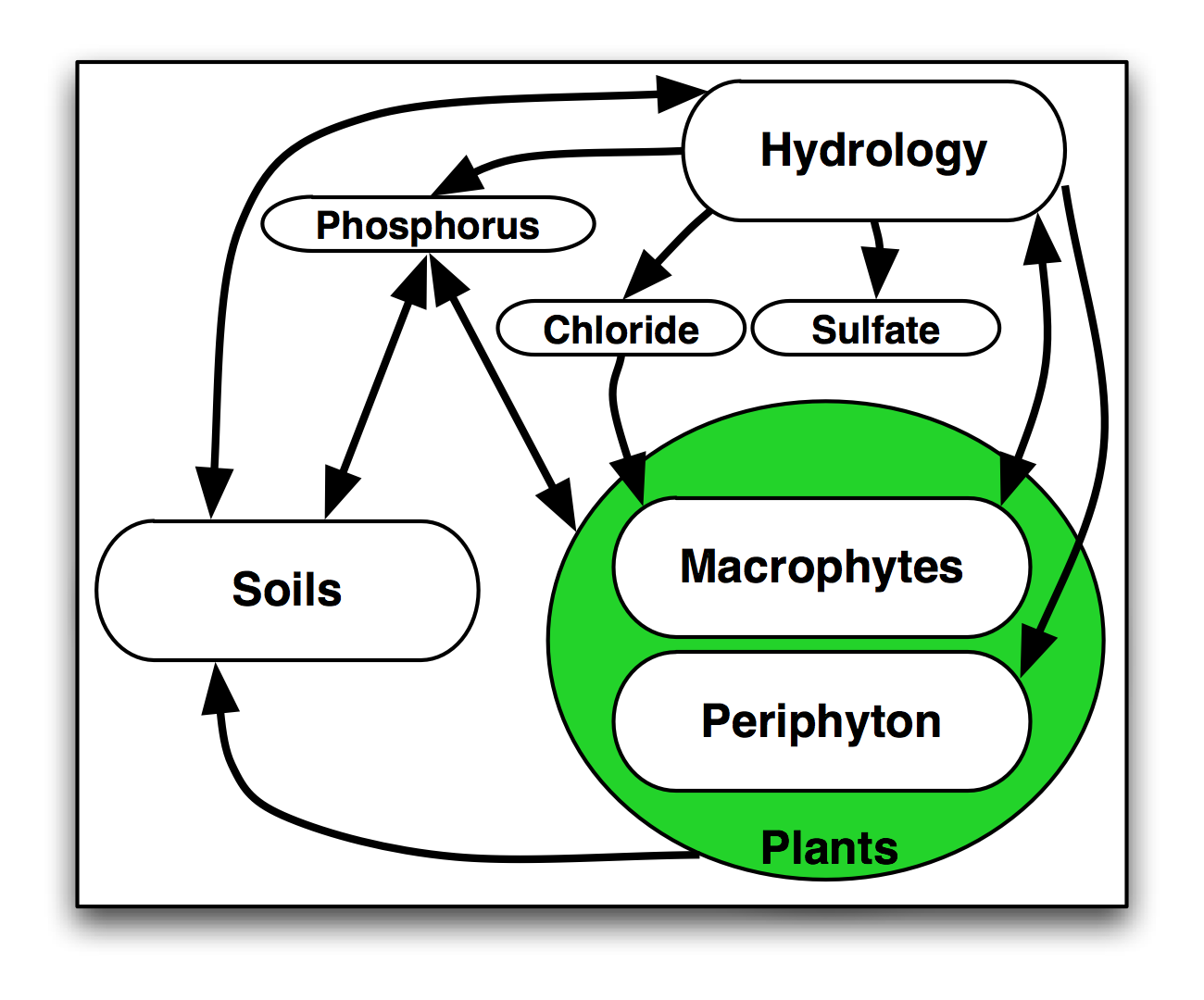 Shown here are the pathways of dynamic interactions among primary modules of a simple conceptual ecosystem - the General Ecosystem Model.
The physical hydrology of wetlands and adjacent habitats is an important driver of their ecosystem dynamics. To better understand the long term ecological effects of altered hydrology, it is important to assess the cumulative influence of the magnitude and timing of the changes. Interacting with these hydrologic dynamics are the nutrient transformations and transport. As the physical and chemical dynamics interact with the biological communities, the system dynamics cumulatively define the transient ecosystem states under different conditions.
Interactions are the essence of ecosystem science. Ecology has been classically defined as the interactions of organisms (including plants) and their environment. For long term planning purposes, a relatively simple model is desired that can capture the cumulative, interactive nature of the ecosystem dynamics, synthesizing the state of our understanding of the general ecosystem processes. The level (or scale) of computational complexity may be relatively coarse, which is dependent upon our current scientific knowledge-base. Fundamentally, there is a need for models that can quantify the relative potential of long-term cumulative ecosystem responses to altered hydrologic and nutrient drivers across the landscape of interest. The challenge is to synthesize habitat change in the landscape, with habitats being an integrated combination of hydrologic, water quality, soils, and algal/plant variables that are simulated with a useful degree of relative certainty. With such a model, the trends in relative habitat change could be evaluated under different scenarios of hydrologic/nutrient management.
The vertical solutions of the landscape simulation are calculated in modules of the 'unit' General Ecosystem Model. As implied by its name, this GEM code was designed to be generic, and applicable to a range of scales and ecosystems. Partly because the GEM was to be applied as a unit model in a large spatial domain, we strived to constrain its computational complexity and data requirements, aggregating ecological processes into those that were hypothesized to be primary drivers of an ecosystem. Concomitant with this rationale for simplicity was a desire to compare differently-structured ecosystems, while using a common model code structure. We avoided process-specific details that may differentiate distinct ecosystems, such as upland forests vs. gramminoid wetlands: instead, we strived to characterize the commonalities in ecosystem processes, keeping each module simple and general.
The framework was crafted to be general to a range of ecosystems and scales. Consisting entirely of Open Source software, the model uses the highly configurable Spatial Modeling Environment (SME) that solves General Ecosystem Model (GEM) algorithms for a range of ecosystems and scales.
 With appropriate (GIS-based) map inputs, and changes to database parameters and environmental forcing data, the modeling (code and data) system can be implemented for a variety of landscapes. Indeed, we are making across-ecosystem comparisons a priority research application of this model.
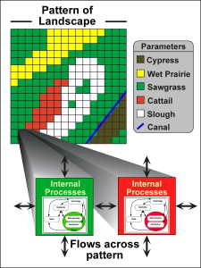
Shown here is the SME conceptualization of how the 'unit' model of general ecosystem dynamics is applied across the heterogeneous spatial grid of different habitat types. Each habitat type within the patterned landscape can be parameterized differently, affecting the internal process dynamics within different grid cells. In turn, the results of the internal processing can affect the direction and magnitude of the flows of water and nutrients across the landscape pattern. Succession, or switching, of habitat types can occur as cumulative conditions warrant.
 The code and data necessary to build and run a modeling project is freely available (under the GNU General Public License) from the Models: Model download link to obtain the latest release of the Open Source Code and data. Not only is the raw code available, it is rigorously documented in hopes of facilitating collaboration among other developers and/or users. See the Publications link for the full model documentation reports for different model applications.
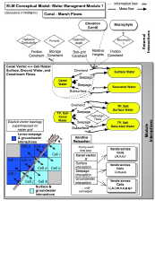
An example of model documentation is shown at the left, which is a graphic of the raster-vector cell-canal interactions that is found in the hyper-linked algorithm documentation section of this site. The model is thoroughly documented at a hierarchical level of detail, ranging from the broad goals & concepts targeted to lay-audiences, to details of code and data that are mostly pertinent to model developers.
No model is complete without data. As with the source code, all data required for implementing the Everglades Landscape Model (ELM) project are freely available as part of the the Model download. Many of those data (e.g., spatial time series database of daily rainfall) are mainly applicable to the landscape of the Everglades. However, many of the ecological parameters may be representative of similar ecosystems in other regions of the world, if only as initial estimates when site-specific data are lacking.
The SME/GEM has been developed for a broad class of ecological landscape model applications, and the Everglades Landscape Model (ELM) is a 'mature' and well-tested instance that continues to be refined and applied. With the greater Everglades region encompassing diverse ecosystem types, this application serves as a useful test bed for continued collaborative developments in landscape modeling in general. From estuarine mangrove forests, to freshwater cypress swamps and gramminoid marshes, and to prairies and upland pine habitats, the landscape poses stimulating challenges to ecological synthesis. Given the range of systems that have been modeled, this framework has significant potential for application outside of south Florida.
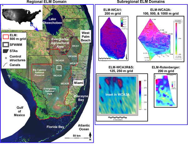
Different problems call for different scales of analysis. In the ELM applications shown above, assessment of regional water quality gradients is accomplished using the ELM with a grain of either 500 or 1,000 meters, across a broad landscape domain larger than 10,000 square kilometers. The same model is being used to explore local ecosystem processes that are responsible for fine-scaled landscape patterns at resolutions of tens to hundreds of meters. Simply changing the input maps and boundary conditions allows the model framework to be used to assess landscapes at a wide range of spatial and temporal scales: the ELM has been applied at annual, decadal, and century time scales, in spatial domains differing by orders of magnitude, to explore research hypotheses or to support landscape management decisions. To the extent possible, this inherent scalability of applications will be maintained as the model framework is further developed.
The ecosystem processes considered in the GEM unit model are a core component of the modeling framework, with spatial interactions being integral to understanding the evolution of the landscape. For the Everglades region, and for other applications, there are a suite of extensions and enhancements that have been identified for further development. For example, while 'hooks' for their incorporation have been designed in the ELM, spatially explicit fire disturbance modules have not yet been incorporated, and are important to exploring vegetative succession in such a fire-impacted landscape. Similarly, the algorithms for succession itself may be enhanced with other rules for neighborhood interactions within a gridded landscape.
Over the years, the SME/GEM framework has been developed and refined depending on the particular application needs - a truly generic model likely does not exist for most ecological problems. However, to avoid the 'reinventing the wheel' problem, our modeling framework provides tested code and data that have been successful in a range of applications. We hope to encourage continued development within this general framework, both in terms of extending the ecological processes that are included, but also in the broader framework itself - to enhance its ease of use, and better evaluate the model results and their uncertainties.
This generic modeling framework is described in more depth in a 14-pg white paper ( 1.1 mb) found in the Publications link in the main menu above.
Moreover, the Models and Projects links in the main menu above provide a hierarchy of descriptions of the topics summarized in this overview of the modeling framework.
EcoLandMod Background