![]() Background |
Models |
Projects |
Publications |
People |
News
Background |
Models |
Projects |
Publications |
People |
News
![]() Background |
Models |
Projects |
Publications |
People |
News
Background |
Models |
Projects |
Publications |
People |
News
Scope of Projects
Everglades regional: Sulfer & MeHg
Everglades subregional: WCA2A Wading Bird Suitability
Florida Coastal Everglades LTER
Everglades regional: SERES project
Spain Segura Basin: Ecological Economics
Everglades regional: CERP ASR
Everglades regional: CERP Decomp
Everglades WCA-1: unique restoration
Louisiana Davis Pond: restoration prototype
Everglades regional: cal/val (ELM v. 2.8)
Everglades regional: cal/val (ELM v. 2.5)
We have a variety of completed and ongoing projects that involve Ecological Landscape Modeling research and application.
Most of these projects blend novel Research model developments into model Applications - an advanced "Prius" hybrid program for 21st century environmental problem solving.
Common to all of these projects is the modeling framework described in the the Background and Models sections (in the main menu above) - incorporating integrated ecosystem simulations in a spatially variable landscape - and usually incorporating some component of the social drivers of the landscape dynamics, whether via water management rules or changes in land use policies.
While we are in the process of applying the model framework to other regions (Louisiana, USA and Segura Basin, Spain), most of the applications described on these pages are targeted to the Everglades landscape in south Florida, USA. For the Everglades examples shown here, we used the EcoLandMod code framework under different scales of data, for different applications of the Everglades Landscape Model.
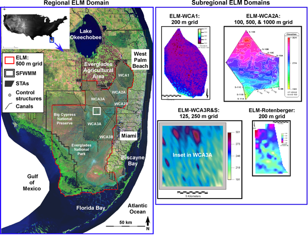
Depending on the objectives, different projects may call for different spatial and/or temporal scales for an application of the Everglades Landscape Model.
The figure below shows most of the existing applications of the EcoLandMod code for the Everglades, using different spatial map inputs to create the applications at each of the different spatial domains (100 - 10,000 km2) at different resolutions (generally from 100 - 1,000 m square grids).
For most Everglades future-planning applications, the available input climate period of record 'limits' us to a 36 yr simulation period (with daily or coarser output resolution); research-oriented explorations of longer-term ecosystem dynamics have been made at century time scales.
The ELM is a regional-scale, integrated ecological assessment tool designed to understand and predict the relative response of the landscape to different water management scenarios in south Florida, USA. In simulating changes to habitat distributions, the ELM dynamically integrates hydrology, water quality, soils, periphyton, and vegetation in the Everglades region. The model has been used as a research tool to better understand the dynamics of the Everglades, enabling hypothesis formulation and testing. This is a critical, ongoing application of the model. However, one of the primary objectives of this simulation project is to evaluate the relative ecological performance of alternative management scenarios.
 EcoLandMod Projects