![]() Background |
Models |
Projects |
Publications |
People |
News
Background |
Models |
Projects |
Publications |
People |
News
![]() Background |
Models |
Projects |
Publications |
People |
News
Background |
Models |
Projects |
Publications |
People |
News
Model Overview
Algorithms hyperlinked
Source code hyperlinked
Model download
Other Open Source tools
 Virtually all of the EcoLandMod work is done using a collaborative 'Open Source' framework, with the models freely available under Open Source agreements.
In developing and applying these models, we utilize a variety of other Open Source software tools.
On this page, we highlight some of the scientific software that we use, and which may be of interest to collaborators.
Virtually all of the EcoLandMod work is done using a collaborative 'Open Source' framework, with the models freely available under Open Source agreements.
In developing and applying these models, we utilize a variety of other Open Source software tools.
On this page, we highlight some of the scientific software that we use, and which may be of interest to collaborators.
 Spatial Modeling Environment (SME version 3): Version 1 of Tom Maxwell's SME is the source code foundation for our
Ecological Landscape Modeling framework. The newer SME version 3 is being used for a variety of other landscape modeling projects.
Spatial Modeling Environment (SME version 3): Version 1 of Tom Maxwell's SME is the source code foundation for our
Ecological Landscape Modeling framework. The newer SME version 3 is being used for a variety of other landscape modeling projects.
 is a code documentation tool that uses special tags we put throughout our source code to automagically generate comprehensive,
hyper-linked documentation of the ELM (and other model) source code.
is a code documentation tool that uses special tags we put throughout our source code to automagically generate comprehensive,
hyper-linked documentation of the ELM (and other model) source code.
 GRASS GIS is an advanced raster and vector Geographic Information System
that has exceptional (comprehensive & fast!) raster landscape analysis methods,
used for our automated (scripted) postprocessing of model output maps, and developing the model input raster and vector files.
GRASS GIS is an advanced raster and vector Geographic Information System
that has exceptional (comprehensive & fast!) raster landscape analysis methods,
used for our automated (scripted) postprocessing of model output maps, and developing the model input raster and vector files.
![]() QGIS is another GIS, which we primarily use as an excellent (ArcGIS-like) interface to GRASS
- particularly helpful for those new to GRASS.
QGIS is another GIS, which we primarily use as an excellent (ArcGIS-like) interface to GRASS
- particularly helpful for those new to GRASS.
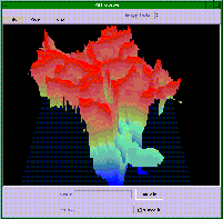
 is an advanced scientific visualization tool (based on IBM's Data Explorer), which we use
for 2D and 3D animations of our spatial time series output data in either netCDF or generic-binary formats.
is an advanced scientific visualization tool (based on IBM's Data Explorer), which we use
for 2D and 3D animations of our spatial time series output data in either netCDF or generic-binary formats.
 NetCDF is a set of software libraries and self-describing,
machine-independent data formats that support the creation, access, and sharing of array-oriented scientific data - we share netCDF-formatted model output with other groups to simplify collaborations. The
NetCDF Operators is a powerful set of computational tools for netCDF data.
NetCDF is a set of software libraries and self-describing,
machine-independent data formats that support the creation, access, and sharing of array-oriented scientific data - we share netCDF-formatted model output with other groups to simplify collaborations. The
NetCDF Operators is a powerful set of computational tools for netCDF data.
 Generic Mapping Tools manipulate geographic and Cartesian data sets,
which we use for accurately reconciling model (netCDF) outputs at different spatial grid resolutions/extents - thus greatly facilitating the integration of models that address different objectives within a region.
Generic Mapping Tools manipulate geographic and Cartesian data sets,
which we use for accurately reconciling model (netCDF) outputs at different spatial grid resolutions/extents - thus greatly facilitating the integration of models that address different objectives within a region.
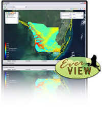 EverView is a very flexible tool for visualizing/animating and
analyzing 2D netCDF data files (that adhere to specific metadata standards).
EverView is a very flexible tool for visualizing/animating and
analyzing 2D netCDF data files (that adhere to specific metadata standards).
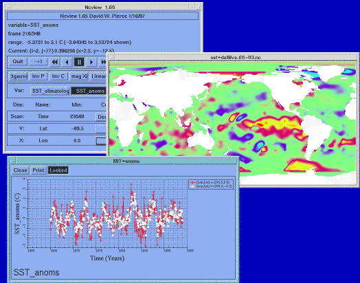 ncview is a simple to use, but very powerful,
tool for visualizing/animating and analyzing 2D netCDF data files.
ncview is a simple to use, but very powerful,
tool for visualizing/animating and analyzing 2D netCDF data files.
 EcoLandMod Models