![]() Background |
Models |
Projects |
Publications |
People |
News
Background |
Models |
Projects |
Publications |
People |
News
![]() Background |
Models |
Projects |
Publications |
People |
News
Background |
Models |
Projects |
Publications |
People |
News
Scope of Projects
Everglades regional: Sulfer & MeHg
Everglades subregional: WCA2A Wading Bird Suitability
Florida Coastal Everglades LTER
Everglades regional: SERES project
Spain Segura Basin: Ecological Economics
Everglades regional: CERP ASR
Everglades regional: CERP Decomp
Everglades WCA-1: unique restoration
Louisiana Davis Pond: restoration prototype
Everglades regional: cal/val (ELM v. 2.8)
Everglades regional: cal/val (ELM v. 2.5)
Primary conclusions from this completed project: restoration of ecologically-beneficial water flows and depths is feasible in this National Wildlife Refuge, without compromising water quality.
One of the unique/innovative aspects of our final model analyses and conclusions: recirculate "clean" water from downstream to upstream portions of the landscape, at very low energy (solar derived?) cost.
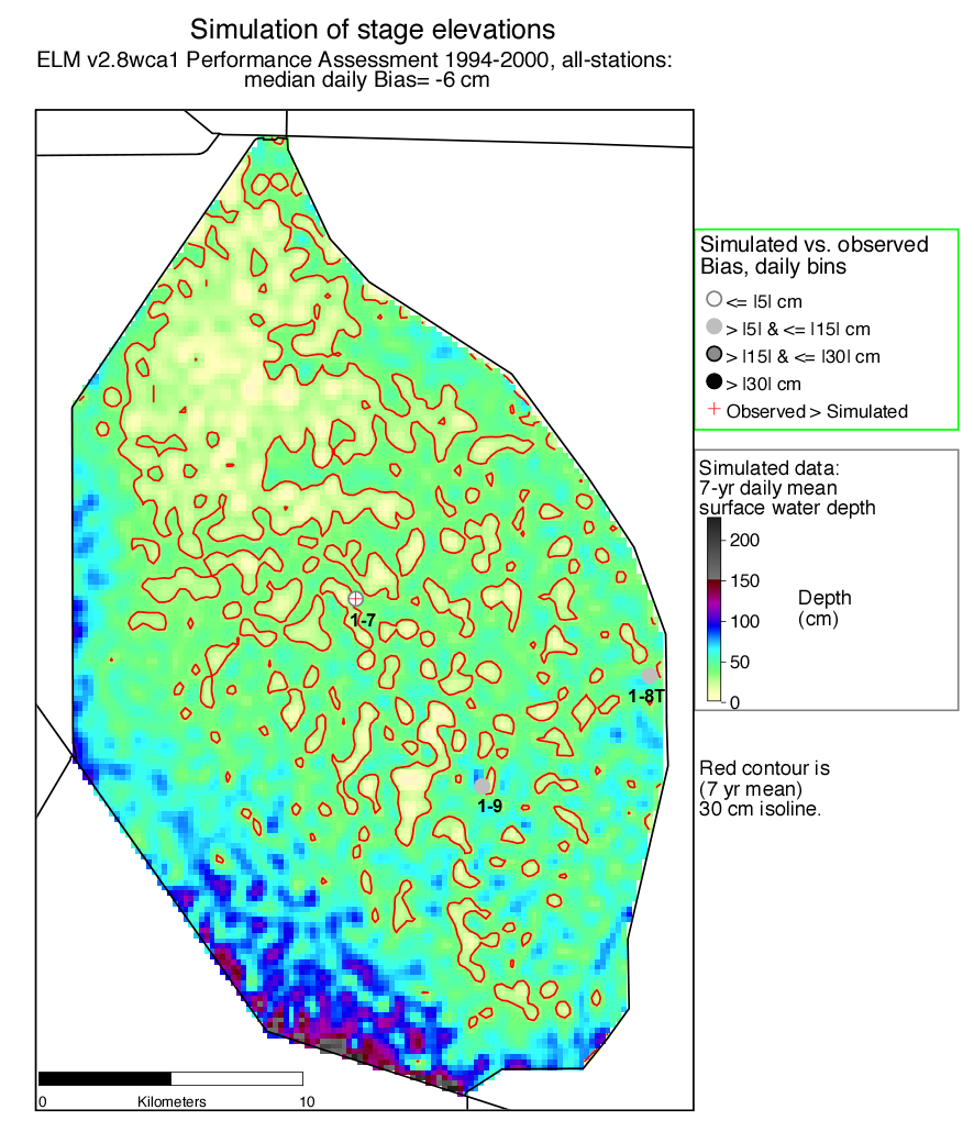
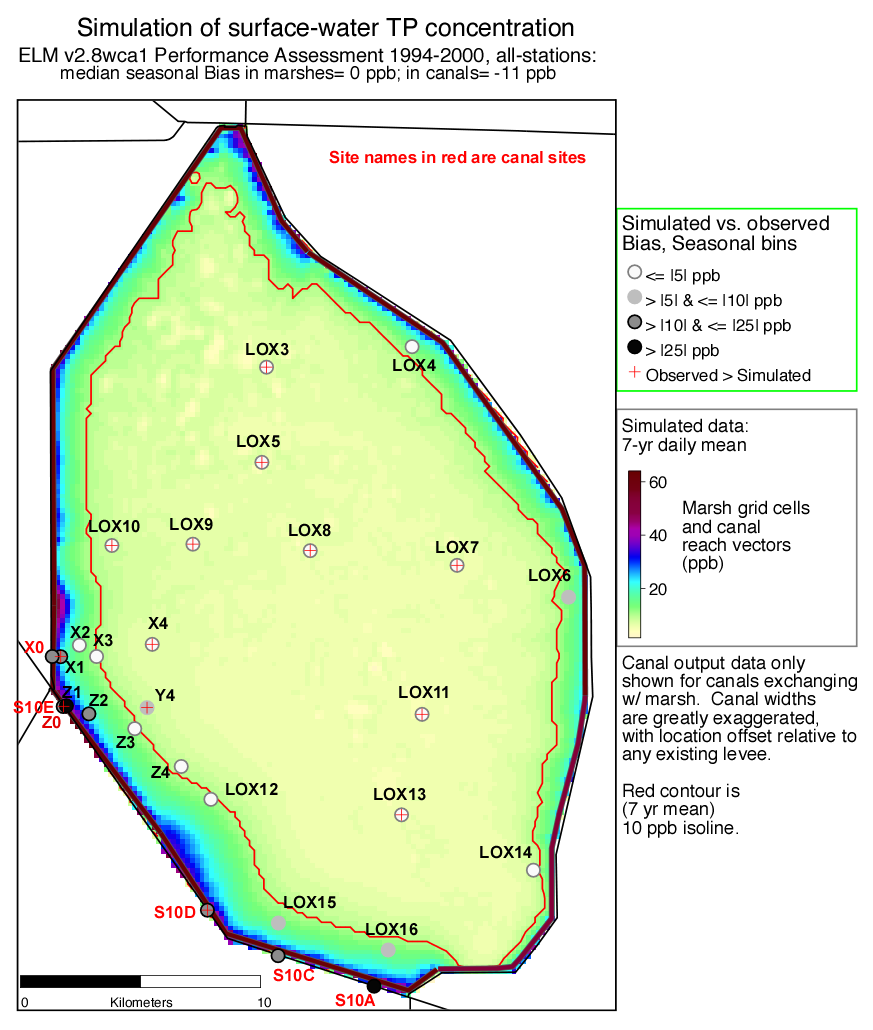
The A.R.M. Loxahatchee National Wildlife Refuge, or Water Conservation Area 1 (WCA-1), is a large impounded marsh in the northern Everglades - and supports a unique and valuable ecosystem that has been degraded in recent decades. For this project, we developed a number of conceptual marsh restoration plans, evaluating their relative benefits among scenarios with a 200 m grid subregional ELM v2.8.1.
Included in this project's objectives is a model analysis of alternative management strategies for hydropattern restoration in WCA-1, while improving current levels of water quality.
Funding for this research and application (extension) project was from the Everglades Research Division, South Florida Water Management District.
A set of conceptual restoration alternatives were developed and evaluated using a fine-scale application of ELM during Fall 2007 - Spring 2008. Referred to now as "Round 1" of analysis, the model, model assumptions, and results were detailed in the ELMwca1 v2.8 Documentation Report provided below. While hydrologic restoration targets were generally met, and water quality in the basin was improved over baseline runs, the team decided to develop and evalulate a "Round 2" of additional restoration alternatives in Spring-Summer 2008. This "Round 2" of modeling resulted in a restoration alternative that generally met both the hydrologic and water quality targets.
Abstract describing the WCA-1 restoration project - presented at the 10'th Annual Soil and Water Science Research Forum at the University of Florida, Sept. 11, 2009 (pdf 70 kb).
The figures below show some of the hydrologic and water quality performance characteristics of the model (which exceeded the performance of the regional ELM v2.5 application).
While rigorous comparisons of simulated to observed data at points along gradients are important in demonstrating model performance, 2D and 3D animations provide a rich amount of information on the model capabilities.
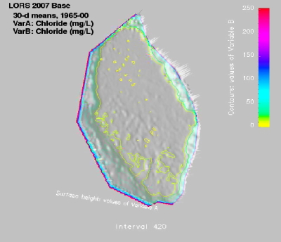
Quicktime movie (MPEG 19.1 mb) ELMwca1 v2.8 simulated surface water chloride (tracer) concentrations in WCA-1, under the 'Lake Okeechobee Regulation Schedule 2007' (LORS07) Baseline (i.e., not restoration) run for future water management plans. Chloride is assumed to be conservative, and thus not "absorbed" or "released" by the marsh during its transport across the marsh - thus, the highly dynamic water flows can be "traced" to and from the canal that encircles the entire interior perimeter of the hydrologic basin. Each frame is a 30-d mean value of surface water chloride concentration, spanning the 438 intervals of the 1965-2000 climate inputs.
(Note: 1965-2000 dates denote the use of historical climate data, which were used as inputs to model simulations of future system responses to future management operations, under historical climate 'drivers' (i.e., what would have happened from 1965-2000 if the system had been operated under the new simulated management rules). The South Florida Water Management District's SFWMM generated the LORS07 managed water control structure flows that were inputs to this ELM simulation run).
ELMwca1 v2.8 Documentation Report - Final version March 31, 2008 (pdf 26.2 mb)
The above Documentation Report does not include the (many dozens of) maps of all scenarios.
The below link contains the zip archive of all map graphics, referenced in Chapter 8. However, it is not 'essential' to download,
as the map Peformance Measures for the 'tentatively selected' scenario are contained in the pdf of Chapter 8.
Map graphics, ELMwca1 application results - March 7, 2008 (zip archive 63.1 mb)
Additional alts for 'Round 2' of modeling, attempting to minimize water quality problems associated with the structure "S5in" inflows of external water.
PowerPoint summary of project results - July 2008 (pdf 4.4 mb).
The pdf below contains a bullet outline of Round 1 findings, Round 2 goals and conclusions (w/ a new tentative selection), and all Performance Measures for most of the Round 2 simulations that were made. For this report, there was no attempt to rank the alternatives in a matrix.
ELMwca1 v2.8: Round 2 of modeling alternatives - May 23, 2008 (pdf 21.6 mb).
Added these on Aug 21, 2008:
Spatial figs: lors07 vs. Recy_SchedRnd2_curt0.75 - Figs create Jul 11, 2008 (zip 8.5 mb).
Screening tool spreadsheet, round1 plus LORS07 - Edited w/ addition Aug21,2008 (xls 0.4 mb).
 EcoLandMod Projects